Offline map, GPS navigation, live traffic, parking, transit routes, and more
2GIS is a detailed map with GPS-navigation for car drivers and pedestrians, live traffic map, transit schedules, and a full city directory. Use it online or download the map to your device to never get lost without an internet connection.
With 2GIS 's maps and navigation, you will feel at home even in an unfamiliar place:
— easily find the address, company, phone number, working hours, goods or services;
— find out how to get there by car, bus, subway, or follow the navigator on foot;
— find an entrance to a building and a parking lot nearby.
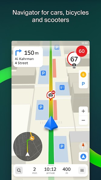
Accurate maps. Locate districts, buildings, streets, bus stops, subway stations, gas stations, sports grounds, and other objects.
GPS-navigation. Considers real-time traffic jams, signs, speed cameras, toll and unpaved roads, builds routes between cities and through several points. There is also a free app for Android Auto.
Live friends' location on the map. Find your kids or friends on the map and ensure their safety with GPS location tracking. You can send fun stickers and see battery charge information. You decide whom to add as friends and with whom you share your location. Manage sharing settings as needed.
Road events. Reports of accidents, blocked streets, and speed cameras, user comments — everything is right on the map.
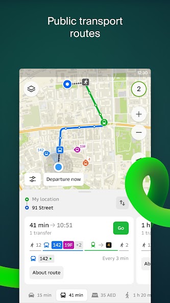
Public transport. 2GIS knows the timetable and online routes of public transit.
Walking routes. Pedestrian navigation paves the way wherever you can go on foot. Works in the background, supports voice guidance.
Navigation for trucks. Cargo navigator gets directions for trucks considering the individual characteristics of vehicles and cargo.
Detailed directory. 2GIS shows addresses, entrances, and postal codes. 2GIS knows phone numbers, working hours, social networks, websites, and entrance locations. Users add photos of companies and write reviews.
Travel guide. Find out about the main attractions, places with Wi-Fi, and more on the map.
A 2GIS Notifications companion app for smart watches on Wear OS.メイン2GISアプリからの自転車、自転車、または公共交通機関によるルートをナビゲートするための便利なツール:マップを表示し、マニューバーのヒントを取得し、ターンまたは目的地のバス停に近づくときに振動アラートを取得します。 The companion starts automatically when you start navigation on your phone. Available for Wear OS 3.0 or later versions.
Available maps:
Cities of the UAE:
Dubai, Sharjah, Abu Dhabi, Al Ain, Ajam, Ras Al Khaimah, Fujairah, Umm Al Quwain, Dibba Al Fujairah, Khor Fakkan, Kalba, Al Salamh, ect.
Cities of Russia:
Moscow, Saint Petersburg, Novosibirsk, Ekaterinburg, Krasnoyarsk, Chelyabinsk, Ufa, Omsk, Kazan, Perm, Nizhny Novgorod, Sheregesh, etc.
Cities of Belarus, Kazakhstan, Uzbekistan, Azerbaijan and Kyrgyzstan:
Minsk, Pavlodar, Semey, Aktau, Aktobe, Almaty, Nur-Sultan, Bishkek, Karaganda, Kokshetau, Kostanay, Osh, Baku, Tashkent, etc.
Support: dev@ 2GIS .com

これらの2024年11月のGenshin Impact Codes、5.1 LiveStream Codesで無料のPrimogems、Mora、Experienceなどを入手し、アクティブコードを引き換える方法を見つけてください。
Metaphor RefantazioのVanillaバージョンのプレイに飽きている場合は、これらの5つのMODを確認できます。
2024年のRobloxのThe Hauntイベントのためのあなたの提出に苦労していますか?ドレスを使用してキャプチャを作成するために感動するガイドをチェックしてください!
ドラゴンエイジのための私たちのウォークスルー:パズル、ボス、仲間、装備、ロマンスなどのガイドを備えたいくつかの便利なヒントとコツがあります。
ドラゴン時代にどの派factを選ぶべきですか:ベルガード?
Sea of Conquest:Pirate Warでいくつかのボーナスリソースをお探しですか?最新の船乗りの景品のために、これらのコードでカバーされています。
」弊社のウェブサイトでは、2GIS の最新バージョンを簡単にダウンロードできます。登録やSMSは必要ありません! 「